What is the BSRTO?
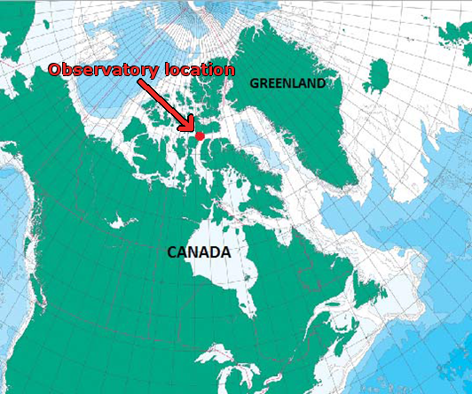
Changing climate in Canada’s Arctic presents both challenges and opportunities. There is a need to monitor the environment to understand the changes, and mitigate their impacts. There is also the need for relevant, up-to-date data to support increased activity and responsible development in a more accessible Arctic.The Barrow Strait Real Time Observatory (BSRTO) is a cabled underwater ocean observatory operated by Fisheries and Oceans Canada (DFO) in the Canadian Northwest Passage. It provides near-real time measurements of ocean properties, ice thickness, water currents, and passive acoustics.
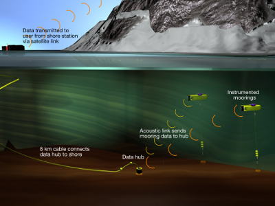
Data from instrumented moorings are acoustically transmitted to a "data hub" at the offshore end of an underwater cable, sent through the cable, and then transmitted from the shore station by Iridium satellite for access on the web.
Acknowledgements:
Defence Research and Development Canada (DRDC-Atlantic) have provided logistical support and shared infrastructure at their Gascoyne Inlet “Northern Watch” camp on Devon Island to help make this project possible. The Canadian Department of National Defence (our CONCEPTS partner) has contributed financial support, and the Canadian Coast Guard has provided the required ship support.
References
James M. Hamilton & Merle D. Pittman (2015): Sea-Ice Freeze-up Forecasts with an Operational Ocean Observatory, Atmosphere-Ocean, DOI: 10.1080/07055900.2014.1002447
Hamilton, J. M., K. Collins, and S. J. Prinsenberg (2013), Links between ocean properties, ice cover, and plankton dynamics on interannual time scales in the Canadian Arctic Archipelago, J. Geophys. Res. Oceans, 118, 5625–5639, doi:10.1002/jgrc.20382.